


Maroc 30-10-2023

honda400xr
User
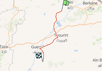

Length
132 km

Max alt
660 m

Uphill gradient
1330 m
Km-Effort
149 km

Min alt
220 m

Downhill gradient
940 m
Boucle
No
Creation date :
2023-10-30 11:13:36.432
Updated on :
2023-10-30 16:47:52.79
2h55
Difficulty : Very easy

FREE GPS app for hiking
 SityTrail
IGN / Geographical institutes
SityTrail World
The world is yours!
About
Trail Trail of 132 km to be discovered at Oriental, Cercle de Louta دائرة الوطا, Hassi Berkane. This trail is proposed by honda400xr.
Positioning
Country:
Morocco
Region :
Oriental
Department/Province :
Cercle de Louta دائرة الوطا
Municipality :
Hassi Berkane
Location:
Unknown
Start:(Dec)
Start:(UTM)
511652 ; 3858544 (30S) N.
Comments
Trails nearby